KENNECOTT
|
KENNECOTT |
|
|
|
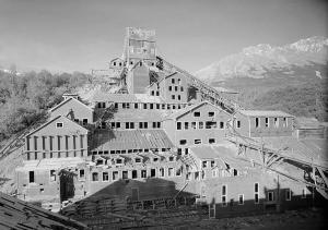
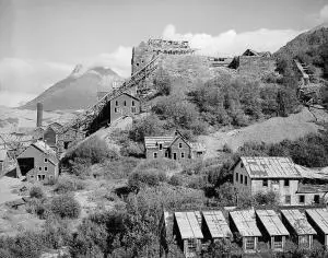
| NAME: Kennecott
COUNTY: "unorganized borough" : copper river basin ROADS: 2WD GRID: 2 CLIMATE: Snow can be heavy. Summers highs are typically 65 to 80F. BEST TIME TO VISIT: Summer only. Otherwise air accessible. |
COMMENTS: Take
the Richardson Highway (mile 0 is Valdez, mile 364 is Fairbanks) to mile
82, which is the junction withthe Edgerton Highway, take that road east
to Chitina, mile 33. Then take the railroad grade (which is upgraded to
2WD use--trailors not recommended) 58 miles east to the Kennicott River.
Here there is parking and campsites available.Across the walking bridge
about 3/4 mile away is McCarthy--a now reoccupied ghost town which is
historically connected with Kennecott.Rides to the Kennecott millsite,
4 1/2 miles north, are available at McCarthy. There is also a museum at
McCarthy in the old railroad station.Lodging and meals are available at
both McCarthy and Kennecott, as are numerous other activities, such as
guided glacier hiking and flight-seeing. |
| See the website. Post office closed with the end of the mine in 1938.This was an unusually high grade copper mine, from which Kennecott Corporation derived its name (from the adjacent Kennicott Glacier).It was connected by the Copper River & Northwestern Railway to Cordova--196 miles away. The CRNW Railway operated a standard guage full servicerailway from 1911 until 1938. A comprehensive description exists on the website.Photos which may be used on the website are the HAER photos, which are public domain.Otherwise, check with me for availability of other photos on the website. Submitted by: Ronald N. Simpson |
|
|
|