BEVERIDGE
|
BEVERIDGE |
|
|
|
|
NAME: Beveridge COUNTY: Inyo ROADS: 4WD GRID: 1 CLIMATE: Warm summer and cool winter BEST TIME TO VISIT: Either spring or fall |
COMMENTS:
A Shangri-La of a town somewhere behind Cerro Gordo. REMAINS: Anecdotes |
|
Beveridge was a Shangi-La of a town that's possibly a part of the Yellow Grade. It is one of the more anecdotal ghost towns in California. Some people in the Owens Valley say they've walked there many times. It's also said that some people in Los Angeles heard the stories, got there by helicopter, and were nearly killed getting out. If you want to try your luck at finding Beveridge, good luck getting back. Other than that, just collect the town's delicious anecdotes. Submitted by: Shawn Jackson You under emphasize the remoteness of the mining camp. I for one know people and have taken trips with people who almost became dirt on the saline side of the inyos. You should post more of a warning for would be seekers of beveridge. In the spring, and fall, a natural phenomena occurs at above the 8,000 ft level, where the jet stream drops and temperatures can plummet to the -30's. Beveridge is inaccessible by 4x4, unless your are talking about the swansea grade which puts you well to the south of the site. The site is best accessed by the beverage trail, which is hidden on the Owens side but is still discernible. there is also a trail on the saline side which takes off from the snowflake talc mine, north of beveridge canyon. The saline trail disappears at about the 4,000 ft level and cross country navigation is necessary for about 2000 vertical ft. another note to anyone who makes it into the site. Drinking water is available in the spring which percolates above the town. The creek that runs through beveridge, is laced with cyanide which has leached out of evap. ponds. The easiest way to reach beveridge is on the owens side. plan at least 4 days for this expedition, and backpacking gear is essential. This trip cannot be made in 1 day. Unless going with someone who has experience, a trek to beveridge is very dangerous due to the camps remote location. I have many pictures of the camp and its mines, and will provide them if you would like. Perhaps the Keynote mine and camp should be mentioned in your site, as with beveridge it is not well known, and lies within a days hike north from beveridge and is a little more difficult to find. I also have pictures of this. Submitted by: Matthew Baumann. Ghosttowns: This is the first time I've visited your website, and I can't begin to tell you what a fantastic site it is. Even though I've only taken a couple actual ventures into "Ghosttowning". My most memorable trip was fondly recalled by your page on the Beveridge Gold Camp in Inyo County, California. The trek started with inspiration from my friend and backpacking partner Dave Beiter of Anaheim. In November 1976, Dave excitedly brought in a copy of Fourwheeler magazine to our office containing the article by Russ Leadabrand titled " Ghost Towning in the Inyo Mountains". Dave frantically pointed out all the intriguing highlights in the article about the "mysterious mining camp back beyond Cerro Gordo", "Beveridge, a lost city that people could or couldn't get to high in the Inyos", or "...a mining camp where the tools, shovels and such, were just lying on the ground...". Well, that was enough for me! My thirst for "unfound" places was whetted, and I could wait to get on the trail. But wait we did while we poured over the maps and ghosttown books, and histories, and whatever else we could find to give us clues to this uncharted Shangi-La of a ghosttown. We made phone calls, wrote letters, and read books and magazines until we had gathered all the information we could to help locate this elusive untouched gem of a gold camp. The best indicators were the 1976 article and the then current 1950 revision of the 15 Minute USGS New York Butte quadrangle map. The magazine article contained all the anecdotal information, directions from several unsuccessful attempts to reach Beveridge, and photo's of artifacts that attested to the existence of the elusive motherlode. The 15 Minute map encompassed all the features described in the magazine, and gave the best pointer of all in the form of the telltale named "Beveridge Canyon" almost directly east of Keynot Peak and Cove Spring. With my nearly brand-new 1977 full-size Jeep Cherokee rumbling under us, Dave and I set out from Anaheim in search of Beveridge on the Friday evening of Memorial Day weekend 1978. We headed north on I-5 to California 14, to US 395, to California 190, and into the Dirty Socks Hot Springs campground on the bottom side of the Owens Dry Lake without any great incident. After any early albeit odoriferous breakfast, we got on the road for Keeler and the turn off for the Swansea Grade. The rough road from the turn-off to the mining settlement at Cerro Gordo was no particular challenge for the new Cherokee despite the warnings signs of "Four Wheel Drive Only". The lunch stop at Cerro Gordo was both refreshing and rewarding. Although we caustiously but yet carelessly drove into "town", we didn't raise the interest of a single human being...if there were any living in the vicinity at the time. The only creature that showed any interest was an old skinny dog that followed along for a few yards, and then sought the shelter of the shade of an ancient picket fence. Dave and I stopped and made a normal amount of noise as we dismounted from the Jeep, and casually walked in and around the main mine shaft buildings...but still we never raised the interest of any inhabitants if they were there. After stretching our legs and quenching our thirts, we got back in our white and black steel charger and headed up the grade. The road became much more of a challenge now, and on the stretch up to Mexican Spring we jammed the Cherokee into compound low, rolled down the windows, and looked down to see all four wheels spitting rocks back down the road behind us. It was along this section of the road that we encountered the rusted, burnt-out hulk of an old IH Scout that apparently didn't have the guts to make it up the grade. At the place that the map changed from a road symbol to a trail symbol, we were delighted to find that the road continued on as a lightly-worn two-track trace that was far from the thoughts of the AAA down in Los Angeles and Orange counties. Once we reached the ridgeline of the Inyos, the road really turned into a tame trail, and we easily attained what we thought to be the high point of the road at the salt tram summit shelter just west of peak 8815. Just past peak 8677 we started to run into large residual snow patches. The Cherokee churned through the first few drifts, but soon the three foot deep mini-glaciers called for several circuitous routes around the deepest snow banks. After skirting the snowfields the road once again became very tame, even though by no means well worn. About a mile past the Burgess Mine diggings the road abruptly ended at about 10,000 feet in a saddle between peaks 10138 and 10668 (New York Butte). Here we got out and surveyed the obvious foot trail ahead that led off around the west face of New York Butte (10668). Since we were now on top of the surrounding world, and there were only a few minutes of daylight left, we decided to sit on the warm hood of the Cherokee and enjoy the last rays of sunset before cooking up our last meal of real icechest food before turning in for the chilly night. The next morning we were awakened early by the brilliant rising sun that pinpointed us from far to the east across the Saline Valley. After disagreeably ingesting our breakfast of dehydrated scrambled eggs, bacon bar, cheese, and crackers; we shouldered our backpacks and briskly stepped out north by northwest on an easy incline that smoothly wound around New York Butte, and then gradually slid down through the saddle at BM9857, and then climbed back up to the pleasant little sage covered plateau at elevation 10186. This trail was nonexistent on the map, but clearly visible and traceable on the ground. From this perfectly flat quarter-mile long table you could see as far as the horizon would allow to both the east and west. The view was breathtaking. So was the altitude! After only about two miles on the trail Dave and I were gasping for air under the strain of our overloaded packs. Just like my Jeep, our carborators were tuned for sea level, and operating up here at almost two miles above sea level... we were running a little oxygen lean. Given the perfect surroundings of this flattop bench that we found ourselves on, we decided that this was where we'd catch our breath and take our lunch. Having dropped our packs, we strolled over to the north edge of our resting place and peered down 4500 feet into the abyss of Beveridge Canyon. From here it was all downhill, and it was going to be easy getting in, but it was going to be a "ball-buster" getting out. We were suprised and very pleased to see the well-worn trail drop down over the precipice of the plateau into the canyon below. It only took a few minutes of discussion to decide that this pathway was the result of footfalls and hoof beats of miners and pack animals, over years of comings and goings to and from the diggings...rather than a recreational trail cut by the USFS or BLM. The other amazing discovering just off the trailside was a pipe driven into the hillside...spouting out a crystal clear, cold stream of pure, delicious mountain water. The pipe was about fifty feet below the top of the bench, and apparently at a point where the seeping snowmelt could be picked off of the bedrock, just below the sponge of the sedimented or decomposed topsoils. Those old miners knew that this was going to be a long dry tramp into and out of camp....and they knew where to find water long before the LA DWP cut off the inlets to Owens Lake. Since we were already used up for the day, and this was such a perfect site, it was easy to decide to pitch down and make an early camp for the afternoon and night. We would have plenty of knee-jarring trail downhill ahead of us the following day (Sunday) to warrant the conservation of depleted energies the rest of this day. So we picked out a likely clear spot amongst a small grove of dwarfed Junipers and set about establishing our first trail camp. Neither Dave nor I were particularly hi-tech campers, so we broke out our cheapy orange vinyl tube tents, and secured then over a peak rope between a couple of the miniature trees. Between the Junipers and the three foot tall sage, there was just enough windbreak to allow the tubes to stand up without a great deal blustering. Later that evening just as we were finishing off our second freeze-dried meal we weere startled by an upwind herd of mule deer that hadn't sensed our presence, and pranced within 20 feet of our camp. Besides being upwind of the mulies, we must have been awfully quiet for them not to notice us. Next morning the sun amplifying through our orange canopies probably made enough colorful noise to wake us up, for we were awakened at an early sunrise hour. Breakfast consisted of some other packaged delights and a fine pot of coffee, and we were set to go for the day. As usual breaking camp takes longer, and is dirtier than making camp; but by 9:00 we were ready for the trail. Then much to our surprise or shock, three human figures boisterously burst upon us from the trail coming up from the deep canyon, and exploding over the lip of the plateau directly in front of us. Dave was an Army vet from Vietnam, and I had served four years in the Marines just prior to Vietnam, and we thought of ourselves as fairly fit (maybe a little lean, but fit); but these three human specimens blew us away with their obvious fitness. They all toted backpacks, and were clad in T-shirts and what I call UDT shorts; and they had muscles bulging out where I wasn't even sure muscles existed anatomically. We greeted each other, and the three stopped to chat and have a drink. It turned out that the men were in fact US Navy UDT members currently stationed at China Lake Naval Weapons Center, and they had decided to do a "hump" up over the Inyos from the Saline Valley to the Owens Valley. Well, that pretty much put my and Dave's trekking expertise into perspective. After our humbling encounter with the UDT men, we packed up and headed down into Beveridge Canyon. We figured that our goal was easily within a one-day downhill hike. It turned out that us "30-something" novice backpakers had enough cartilege and sinew to get us down safely to an incredible stone cabin at the 6600 foot level. The trail all the way down (except for the first 1200 feet) followed a series of switchbacks and verdent green north-facing slopes in deep moist-bottomed crevices. The south canyon walls were bursting with wildflowers, bright green sage, ferns, junipers, and other small evergreens. The north sides were burnt out and barren except for the stunted plants that stuck themselves in the crevices between each and every rock. We had read about the two-room stone-walled cabin with the corrogated tin roof; and there it sat just as described at the confluence of the streambeds at about 6600 feet. The hand-carved sign over the tree-framed doorway says, "Green Bear Placer Claim, Welcome Use With Respect". We respectfully used the cool shade within the cabin to get some rest and have an energy restoring snack. We sipped the water from our jugs and canteens, and did not partake of the cooler looking stream water due to the warnings of cyanide leaching into the beds from all the mining activities in the area. The trail headed down canyon through a virtual green lawn of local grass, while the streambed was lined by rushes and other moist-growing vegitation. This was surely a remarkable setting if you could get past the trek it would take to get to and from it. Another 3/4 to a mile down canyon from Green Bear, and at the next stream confluence at about 6200 feet elevation we were astounded to see a series of human built structures. Even after encountering the structure up-canyon, for some strange reason my mind was still programmed to find large wood bildings like we saw down at Cerro Gordo. What were we thinking? There was some small willow brush in the moist bottoms of the canyon, and there was scarcely a tree. In 1877 when W.L. Hunter founded the Beveridge camp there wasn't any Home Depot to purchase lumber from. Those folks were going to have to do with whatever materials were available within the immediate area. So what did they build, and what did we find? - Though we couldn't recall an exact number of structures that we found, it seems that it was somewhere around 10 or 12, with only one (other than Green Bear) that actually could be described as a full-up "cabin". It was situated on a built-up little rock-lined terrace on the north side of the streambed. It's walls were the same intricate jigsaw puzzle of odd-sized and shaped rocks as the Green Bear Claim, fitted together to form an amazingly strong interlocked structure. There were window holes on two sides that were framed with old wooden boxing material, and a doorway whose 6-foot tall frame would have smacked me right in the forehead of my 6'4'' frame if I hadn't ducked. The one-room layout was only about ten feet wide by 18 feet long, with a hard packed dirt floor and an upright rough pole supporting the ridge beam of the branch/stick/semi-thatched roof. There was a wooden shelf still intact, and because of first impressions we called this place "the general store". The only other manmade item inside was a yellow BLM sign with either brown or black lettering to remind us of the basics of the Antiquities Act regarding the removal of artifacts. The other structures were best described as rock shelters, and usually only contained sides, but no roofs. One or two were walls extended out from a large overhanging rock in the canyon side. We imagined that in some of the other flat places there may have been some tents erected. While there were no strong signs of vandalism that the BLM archealogist in Bakersfield had warned us about, there certainly weren't any of the artifacts just laying around as described in Leadabrand's article. The scarcity of artifacts seemed to heavily reinforce the story about the "looters" who had swooped in with their helicopter, and made off with everything they could carry. In place of the stolen artifacts the BLM could do nothing but leave a half dozen of the yellow signs to warn the rest of us late-comers not to destroy what was left. Since it was still early in the season the willow brush wasn't thickened up yet, so we had a pretyy easy time of going down canyon to examine the remains of the stamp mills. If it was difficult to believe that men had trekked in here and built up the stone shelters, and lived and worked back in this desolate crevice; and it was almost impossible to believe that the parts and pieces of the mills could be hauled up or down into this place, and put together to do their work. Well by now it was getting early into the afternoon on Sunday, and our plan of day-hiking down into the canyon with only our light gear called for us to get back on the trail. We hoped that we would have enough daylight to get back up the 4000 or so feet to our base camp where we had left our backpacks and tube tents. Thankfully the depth of the canyon left the trail fairly shaded, but we would still have to slog our way up the steep trail that was pinched in and overgrown with a variety of prickly and thorny brush. When I recently asked Dave what he remembered most about the trip, he said two things: 1) the damned thorny overgrown brush on the trail, and 2) how good that water felt and tasted when we got back up to the piped spring at the top of the climb out. We got back up to our camp well before nightfall, but mighty wornout. The uphill fight against the brush had taken a lot out of us. We were glad that the UDT guys weren't around to see us come huffing and puffing up the same trek that they had apparently done with little or no ill effects. After a good rest and an awesome sunset, our last dehydrated dinner was served up and wolfed down. Then we gladly slid our sore bodies into sleeping bags, and were sound asleep long before the moon took control of the nighttime sky. Memorial Day morning had us up early to the revielle of the eastern sunrise, and we eagerly packed our gear not bothering to spend the time putting together another freeze-dried breakfast. The trail back to the roadend seemed like a stroll in the park compared to the previous day's haul, and we were back to the Jeep by 9:00 am. Our gear was stowed in the back of the Cherokee quickly, and we pointed it south down the ridgeline road. We ate our snackfood breakfasts as we eased down the easy path toward and past the salt tram summit. We took in the breathtaking views on both sides of the ridge as we drove, and discussed the worthiness of our adventure. A few thoughts were concluded as we drove back to civilization as we knew it: 1) the desire for gold must indeed be strong to drive men into such a desolate place, 2) the draw of this isolated storied place was strong enough to pull us down into that same desolate place, 3) we were glad and satisfied that we had done the trip, 4) we would probably never make this trip again, and 5) we would neither recommend for or against this trip for anyone else. After recently visiting the Beveridge Canyon Trail webpage on the Ridgecrest BLM site, we see that a lot has taken place in the last 23 years, and a lot more information is available for adventurers who are thinking about visiting the gold camp. The data that was grudgingly passed to us in hushed tones in 1978 is now readily accessible at your finger tips. The BLM information is obviously very accurate, and can be used to help you decide about this destination. If you are expecting to see a "ghosttown" like Bodie....don't go. If you're fit, and you prepare properly, and you want to have some experience of what the old goldseekers must have encountered....then by all means go. And since this is such a storied, fabled place....you'd better bring your camera, so you can prove that you were there! -Glen Roosevelt |
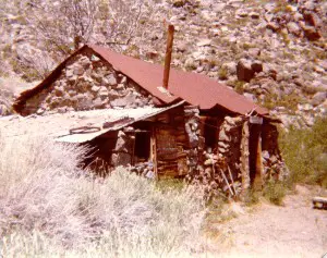 Green Bear Claim located near Beveridge Courtesy Glen Roosevelt |
|
|