BAYPORT (BAY PORT)
|
BAYPORT (BAY PORT) |
|
|
|
|
NAME: Bayport (Bay Port) COUNTY: Hernando ROADS: 2WD GRID: 3 CLIMATE: Florida weather...hot most of the time, especially summer. BEST TIME TO VISIT: Anytime |
COMMENTS:
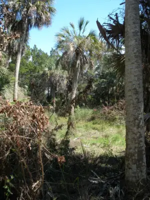
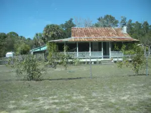
You can get to Bayport by taking Highway 50 (Cortez Blvd) west from Highway 19 at Weeki Wachee. You will first pass through the north end (Coogler's Beach) where there are a handful of residences. Once you reach the park at the terminus of the roadway, you will be at the former townsite, which is now primarily owned by SWFMD. Just north of the park entrance, there are a few older houses along Cortez and some of the former streets, which are barely discernible. The former townsite has otherwise been reclaimed by nature and is all but grown over. REMAINS: Very little to none from the original townsite. A few barely discernible dirt/gravel road and some older houses. The original townsite is mosty grown over. |
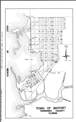
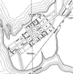
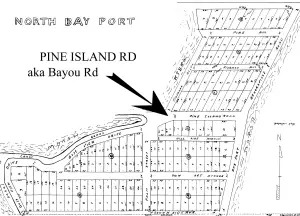
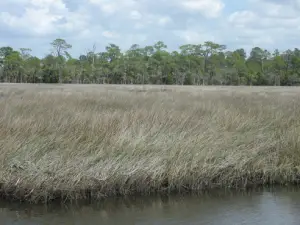
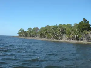
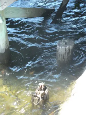
| The town of Bayport in Hernando County is at the western most terminus of HWY 50/Cortez Blvd. The original town site no longer exists, as it is now a public park and boat ramp. There are a few dwellings from the early 20th century remaining just outside of the park entrance, but much of the land was deeded to South West Florida Water Management District (SWFMD) in 2000-2001. According to the web site www.fivay.org Bayport was originally formed in 1842 or 1852. �On August 12, 1852, Thomas Henry Parsons (age 30 in Cedar Key in the 1850 census) purchased property in what would become Bayport. His home became the Bayport Hotel, which was destroyed by a fire on Oct. 17, 1943.� (Fivay.org) The Weeki-Wachee River and Mud Creek join at Bayport where they then exit into the Gulf of Mexico. Bayport and Pine Island's low-marsh surrounds are an excellent example of undisturbed Florida beauty. However Kirk Munroe, who paddled over 1600 miles of Florida waters from 1881-1882 described Bayport in his journal as "beastly, dull, uninteresting place, one store and four or five houses all owned by Maj. John Parsons. " Bayport was instrumental as a small port on the Gulf Coast. Prior to the Civil War goods were shipped in and out of the small port, such as cotton, citrus and meats. During the Civil War a Battery was built at the edge of town on the river, complete with canons which fired grapefruit sized rounds. The remains of boiler tubes from Confederate era blockade runners boats can be seen on the Battery which is now part of the Bayport Park. After the Civil War the town rebuilt and continued shipping. The town continued to function as a port and tourist destination until the death of John Parson's in 1888. The Coogler family purchased quantities of land soon there after. The hill just north of Bayport is now noted on maps as Coogler's Beach. Eventually the Bayport Hotel would be the only business in town. The doors of the Bayport Hotel closed eventually and burned to the ground in the 1940's. (Fivay.org) Coogler's Beach is a few winding streets on a hill leading to the marsh. Bayou Drive snakes into the marsh to the west, as it was the original road to Pine Island. Now there is a connector road to Pine Island Road at the current Bayport Inn. However Bayou Drive offers a lazy, well paved but narrow drive through the marsh with an excellent view of the surrounding area. A 1916 plat map (courtesy of Hernando County Property Appraiser) shows an extensive network of streets, however most were never developed. The areas referred to as Dr. Bruner is still occupied by residencies. When compared to satellite imagery from the 1940's and today much of what is platted as solid ground has never been more than marshy grassland. Access to the original streets of Center, Bay, School, High and Main is prevented due to the land and right of way being vacated to SWFMD. For a detailed history of the area and information about the Bayport cemetery visit the extensive web site of Jeff Canon at "http://pascocemeteries.org/hernando_bayport_history.html" Submitted by: Erik Ransom and Dara Vance |
|
|
|