GOTEBO
|
GOTEBO |
|
|
|
|
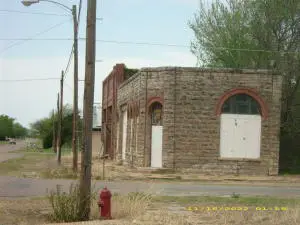
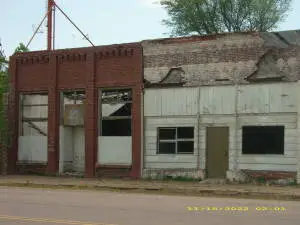
NAME: Gotebo COUNTY: Kiowa County ROADS: 2WD GRID: 2 CLIMATE: Cold in Winter, Hot in Summer BEST TIME TO VISIT: Anytime |
COMMENTS:
There are some residents still living in and around. No stores, only an abandoned downtown and abandonded buildings. REMAINS: Lots |
|
A few residents still live there among deserted and abandoned building and houses. Submitted by: Mollie I visited Gotebo, OK on 26 July 2009. Gotebo, named after a Kiowa Indian Chief, is located at the intersection of State Hwy 54 (north to south)and Farm to Market (?) road 9(runs east from U.S. Hwy 183about 6 miles due south of Rocky, OK), Given the EXCELLENT pictures already on the site, it was easy to find the street on which these structures are located. I have other pictures, which I will be able to submit in due course (I hope). Although these pics make the town appear desolate, there is a small community which has grown around these old buildings. I can add further info on the two excellent pics submitted by Rayn. 1.) The top pic is of the entrance to the (former) American Legion Post 190, located at 410 W. Commercial Street. There is a step in front of that door, on which is embossed a circular government seal from the "Coastal and Geodetic Survey System". The circle is bisected horizontally. Above this line are the symbols "X 30". Beneath this line is the year (1934) in which is was evidently affixed. No overt mention of the elevation of Gotebo (1430 ft) was found on it. 2.) If one could pan left in the first picture, across the street, the City of Gotebo Municipal Building would be visible. At the doorstep of this building is some sort of mosaic tile spelling the word "BANK", so the origins of this building are partially knowable. 3.) Panning to the left again, across the intersecting road (diametrically across the intersection from the American Legion Hall), There is a fairly narrow though quite deep building. The sides of the building indicate "turn of the(20th) century" masonry and rocking. The front shows off someone's attempt to modernize the facade in blue, though with little success. Evidently, this building was a beer hall, named "Goat Ropers" as evidenced by the black lettering on the facade. 4.) The second picture depicts buildings to the east of the A.L. hall. Not seen in the picture (further to the right/east) is a storefront facade of apparently original achitecture with the Inscription "H.H. WEBEL" below which is the year 1900 or 1906. Next to this building or perhaps another store further to the east was another establishment with "DAISY" written above it. Whether this is original to that building's facade is not clear to me. I'm less certain about its orgins than the "WEBEL" inscriptions. 5.) There were no "NO TRESPASSING" signs that I could see from the front of the buildings, but the roof collapses and genrally lowered structural integrity of most of the stores make exploration ill advised. At least one segment of the building, to the west of the American Legion Hall, looked as though the collapse had been the result of a fire. 6.) Local residents seem to think that these buildings are suitable for nothing more than dumping their unwanted electrical appliances and other items within. |
|
|
|