KIMBALL
|
KIMBALL |
|
|
|
|
NAME: Kimball COUNTY: Bosque ROADS: 2WD GRID: 3 CLIMATE: Warm winter, hot summer BEST TIME TO VISIT:Winter, spring, fall |
COMMENTS: It is a challenging and hard hike, but is well worth it, because there is 4 buildings and one old silo with many artifacts from the early 1900’s (bottles, tools, items that would be found in barns for that era) . REMAINS: Unkown. |
 |
|
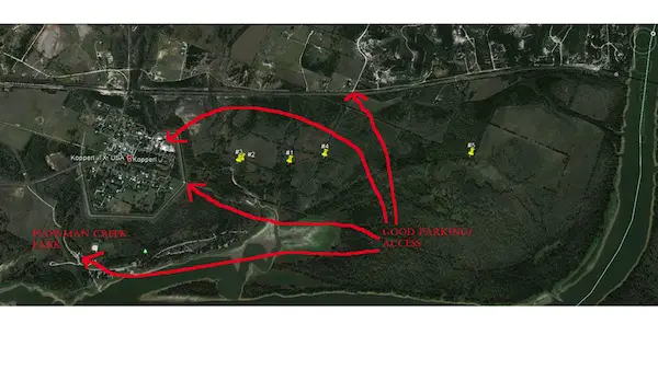
Richard B. Kimball, a NewYork lawyer, and an associate founded the town about 1854. Kimball was located on the Chisholm Trail where it crossed the Brazos River. This was the place where thousands of cattle crossed the river on the way north to Abilene and Wichita, Kansas. It required about ten years before Kimball began to grow into a town of any importance and that was when the cattle drives north crossed the Brazos at Kimball. The demise of Kimball began in 1875 with the shift of cattle drives to the westward. In 1881, the Santa Fe Railway laid track through the region missing Kimball by several miles. The town, in time, became little more than a wide place in the road. In the late 1940s, the U.S. Corps of Engineers bought out the few remaining residents to make way for the construction of the Whitney Dam on the Brazos River. The townsite today is in Kimball Bend Park at the south end of Texas Highway 174 in Bosque County. SUBMITTED BY: Henry Chenoweth If you are going to try to find the remains of Kimball, plan to spend an entire weekend hiking and exploring. Take appropriate hiking gear, because some areas are thicker than others and getting lost is a major possibility (especially in the spring when everything is thick and tall). The first step is to stop at the Kopperl Volunteer Fire Department, and hope that someone is there, you can call their phone and setup a time for you to visit. In the KVFD (Kopperl Volunteer Fire Department) there is hundreds of pictures of the area ranging from the late 1800’s to present, some of which showing the buildings that are in what used to be Kimball. The people of Kopperl( a small town about 300) are very kind people that will help you find the old town (I know this because I belong to the KVFD). A gps with the coordinates I list would be the best way to find these buildings. Wear bright colors or an orange reflective vest, this area is a hunting area. I used google earth to show the pin points, these are not dead on exact, they are with in a 200’ diameter of being accurate, so if you get where my coordinates take you and you don’t see anything start searching around, these buildings are very very old and the greenery could be hiding them a little. |
|
|