|
This is an update to Vineland, FL as of April 2009:
During a recent visit in April 2009 it was observed that the majority of the land bordered by Ruby Lake Rd to the west, Lake Rd to the south, Fenton Rd to the North and Palm Parkway to the East is now privately owned by various resort owners and developers, including Hyatt, Diamond Resorts and Ravallo Resorts.
The town of Vineland can now be accessed by driving north from I-4 on Apopka-Vineland road then turning right onto 5th Street and then turning right onto Ruby Lake Rd heading south. Many of the streets that bisect Ruby Lake Rd are nearly gone. 6th street is no longer accessible as it is part of the Montessori school. About one and a half blocks of 7th street is accessible to the west, as it runs in front of the school, which was built in 1950. 8th street is the most well preserved, with about two blocks running to the east and one and a half running to the west. To the east, 8th now dead ends at a fence blocking access to the lake. To the west 8th terminated at the train depot but now simply dead-ends at wooded property owned by Florida Power.
9th Street, which has a large median, led to Lake Ruby but is now blocked by a fence to the east. 10th street is barely discernable in the woods. 11th street to the East leads to a large gravel lots and is also fenced. To the West 11th street is a grassy path leading to two residences behind a shopping center. Continuing south on Ruby Lake, turn left on Lake St and continue about ½ a mile to Oak Street on the left. The street is asphalt with a curb and leads to one abandoned house built in the 1960’s. The rest of the surrounding land is slated for resort development.
Commercial, Pine, Orange and Palm (also labeled as Olive) streets, that ran north and south and intersected Lake are now inaccessible and covered over. Palm (Olive) and Oak streets are being plowed under in the resort development.
Continuing to the north on Apopka-Vineland you will find 4th, 3rd, 2nd and 1st streets that have minimal residential development. As Apopka-Vineland Road expanded from the rail bed, to country road to its final 4 lane highway status, the residencies have ended up closer and closer to this heavily traveled road. If you continue about 1 mile north of Vineland you will come across Fenton Rd. This is a paved road that has fallen in to disrepair. To the east Fenton leads about a mile and a half to a former gun range site that is now Dr. Phillips park area. To the West Fenton leads to half a dozen residences in the woods. There is rumored to be a Confederate Cemetery off of Fenton Road.
Submitted by: Erik Ransom and Dara Vance
As above
Submitted by: Patty Mack McGinnis |
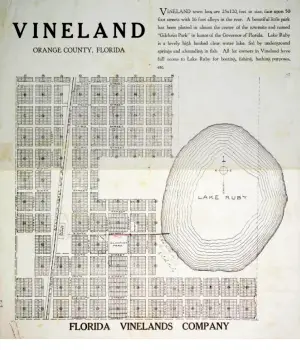
Vineland Map
Courtesy Dara Vance and Erik Ransom
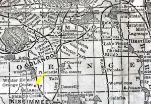
1920's map - Note Vineland is known as Orange Center but later changed the name so as to avoid confusion with Orange City
Courtesy Dara Vance and Erik Ransom
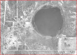
Aerial map of Vineland circa 1947 - courtesy PALMM
Courtesy Dara Vance and Erik Ransom
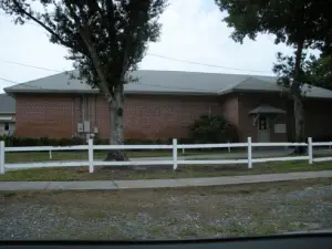
7th Street School - built 1950 according to Orange County Plat Maps
Courtesy Dara Vance and Erik Ransom
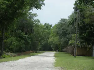
8th Street looking west towards where the ACL Depot would have stood.
Courtesy Dara Vance and Erik Ransom
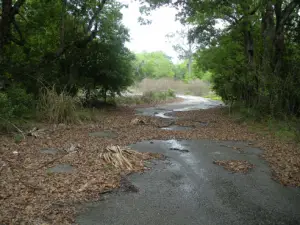
9th street looking east.
Courtesy Dara Vance and Erik Ransom
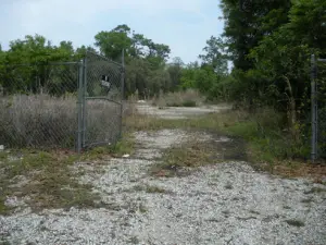
11th street looking east
Courtesy Dara Vance and Erik Ransom
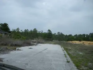
Oak Street looking north. The large piles of dirt are the result of Ravallo resort construction. Not much has been built other than a road.
Courtesy Dara Vance and Erik Ransom
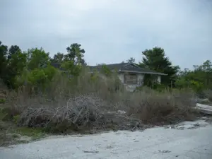
House on Oak St. abandoned and boarded up. Circe 1960 according to property appraiser
Courtesy Dara Vance and Erik Ransom
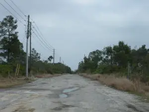
Fenton road looking east - it is paved but quite rough in spots. There would be a lot of mud if there was a recent rain.
Courtesy Dara Vance and Erik Ransom
|