|
History on this town is unknown. Might of been a mining town for the r.R. In the 1850's to the early 1900's. Locals would know more. Try stopping at carriage hill historic farm for more info.
Submitted by: Philip Campbell
Tadmor
The Nation’s Crossroad of Transportation
The village of Tadmor, just east of Vandalia on the Miami River, was never very large,
but yet, it was an important center of transportation in the 19
th
century. It was located at
the crossroads of every means of transportation of its day.
The Miami Canal was started in Cincinnati in 1825. It was dug by Irish and German
laborers and local farm boys for 30-3/4 cents and numerous jiggers of whiskey per day.
The canal was 40 feet wide and 4 feet deep, just wide enough for two canal boats to pass.
By 1829 it was open to Dayton. In 1832 over a thousand passengers a week were using it
even though the locks at the Ohio River were not yet completed. Cargo still had to be
off-loaded at the city and taken by wagon to the river.
The Miami Extension north from Dayton began in 1833 and work on the great Miami
aqueduct began that same year. It was located just a mile south of what was to become
the village of Tadmor. Work progressed slowly through hard economic times but the
canal progressed through Troy in 1837. It finally linked up with the Walbash and Erie
Canal eight years later and became known as the Miami and Erie Canal.
The farmers in Western Ohio could at last get their products to markets in the south and
the east. Subsistence farming was a thing of the past. Flour, whiskey, pork, lard, apples,
nursery stock and grain were all shipped by way of canal boat and brought cash to the
farmer.
By the time the canal reached Troy, the National Road was approaching Butler
Township. Construction had begun in Cumberland, Maryland in 1811 and was slated to
connect the Capitals of the states by the shortest route. The clearing for the road was to
be 4 rods wide, and no elevation was to be more than 5 degrees. Since 1824 all repairs to
the old sections and the new construction were to be on the Macadam System – small
broken stones that would interlock for a hard surface.
In 1837, bids were let for the road 8 miles west of Springfield, and the farmers were
warned to get their crops from the fields for its construction. The covered bridge over the
Miami River was built and the road crossed the Miami Canal. Two almost right angle
turns took National Road through the escarpment and on through the newly platted town
of Vandalia.
The abandoned section of the old road between the present railroad and The Falls is
probably one of the few in the country which still retains its 19
th
century appearance.
Although the National Road became a toll road it was never self-supporting. For many
years the width of the vehicles’ wheels determined the toll since narrow wheels caused more road damage than wide. A score of sheep or hogs cost 5 cents, a horse that was led
or driven was 3 cents and a horse and rider paid a 5-cent toll. Thousands of head of stock
were driven to market, and at time, there were lines of wagons of families going west for
settlement passing freighters carrying produce to eastern markets and manufactured
goods west for the settlers. It was truly the National Highway.
The Dayton and Michigan Railroad was incorporated in 1851 and by 1853 was running
regular excursions from Dayton to Troy. Progress brings change, and, ironically, the
proliferation of railroads drastically curtailed the traffic on the canals. Railroads did not
freeze over in the winter, wash out with spring rains or suffer from drought.
After returning from the Civil War, Walter Crook became the postmaster, station agent,
warehouseman and grain dealer at Tadmor. The foundation of his house is still visible.
The railway depot was between the curve of the road and the tracks. There are stories
that the second floor of the depot housed Hungarian railroad workers. Perched on the
edge of the canal next to the covered bridge was the canal keeper’s house. At one time
his front room was the grocery store and post office.
A house and barn was located on the hill overlooking the depot, and there was a farm
near the river to the south. An access road crossed the canal to two houses near the river.
That road might well have run to a ford for livestock so they did not have to be herded
through the covered bridge.
When the 1913 flood destroyed the canal, floated some buildings down river and
necessitated moving the railroad tracks to higher ground, the National Road was still
intact and the covered bridge still spanned the river. But, when the road was re-routed
over Taylorsville Dam the residents left, and the world by-passed the village of Tadmor
forever. Tadmor never became a city, and it never became well known, yet it remains a
very important slice of this country’s transportation history.
The Park District of Dayton-Montgomery Co. is maintaining interpretive signs of the
village and is mowing the Buckeye Trail which follows the old tow-path through
Tadmor. It has built a parking area accessible from National Road just west of
Taylorsville Dam on old Canal Road. From this parking lot the aqueduct abutments are
easy walks. Perhaps the Village of Tadmor will no longer be by-passed by the world.
Dolly Lewis |
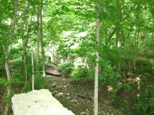
Other side of the locks in Tadmoor. Taken by Dawn Veihl, Tipp City, OH Summer 2007
Town: Tadmoor
Courtesy Dawn Veihl
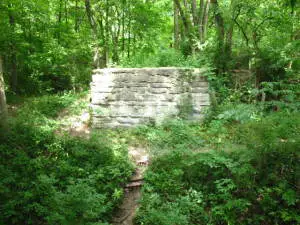
One side of the Locks in Tadmoor taken by Dawn Veihl, Summer 2007-Tipp City, OH
Courtesy Dawn Veihl
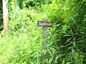
This sign is located off the path and down an overgrown hiking trail off of Ross Road in Tipp City/Vandalia. Taken in Summer of 2007 By Dawn Veihl
Courtesy Dawn Veihl
|